
RE 102 — Fort Roberts
, just opposite to the Bala Hissar, which can be seen in the middle of the left photograph. The two panorama photographs RE 074 and 075 were taken close by.")
Panorama. In the centre of the right photograph is the massive construction of the so-called ‘Fort Roberts’ constructed by the British troops on top of Tapa Maranjan (at that time also called Siah Sang), just opposite to the Bala Hissar, which can be seen in the middle of the left photograph. The two panorama photographs RE 074 and 075 were taken close by.

Left part of panorama RE 102.

Right part of panorama RE 102.

Panorama. In the centre of the right photograph is the massive construction of the so-called ‘Fort Roberts’ constructed by the British troops on top of Tapa Maranjan (at that time also called Siah Sang), just opposite to the Bala Hissar, which can be seen in the middle of the left photograph. The two panorama photographs RE 074 and 075 were taken close by.
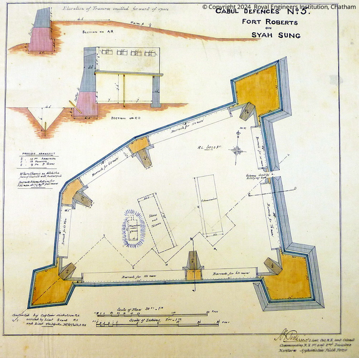
[Album:] Photo. No. 7. / Fort Roberts. (Works Drawing No. 5). Photograph to show the position of the Fort with reference to the Bala Hissar. – Fort seen on right of foreground. – Consider in conjunction with Photographs 8 and 9.
[Captions on top:] ↓ Takht-i-Shah; range from Fort Roberts, 4550 yards. / ↓ Kotul / ← Shahr-i-Darwaza → / ↓ Deh Mazung Gorge / ↓ Asmai Fort / ↓ Fort Roberts.
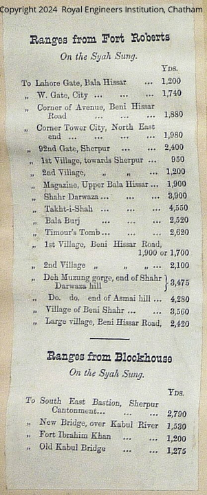
[Printed table with ranges from Fort Roberts and from Blockhouse]
- Original:
Chatham: Cabul Defences, Photo No. 7, “Green Album”, No. J1 6/256 - Collection Cabul Defences, Plan No. 5: “Fort Roberts on Siah Sung.”; No. 5 A: “Fort Roberts on Siah Sung. / Sectional Elevation on E F G H K L see Plan No. 5.”
- Not in the albums of the usual RE Collections.
- Sammlung Luise von Segnitz, vS 235 + 236: Photograph of Fort Roberts, taken on March 12, 1938.
Image No.
RE 102
Collection
Royal Engineers Museum, Library and Archive 1878-1880 1878-1880
Series
RE 100-115, Confidential Photographs/Plans
Format
Two albumen paper with gold toning, 205/280 mm, on brittle, brown paper with printed captions
Quality
good, faded
Place, date
Kabul, spring 1880
Descriptors
Latitude / Longitude34.514435 / 69.204694
Google Earth34°30'52" N / 69°12'16" E / 1850 m
Google Mapshttps://maps.google.com
Zoom Earthhttps://zoom.earth
Survey of India MapSheet 38 (1917), Kabul: Kabul, 2B 26
You know more about this picture?