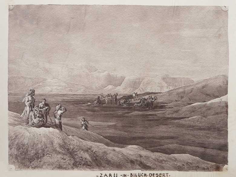
ELD 003 — In the Baluch Desert
Sepia-toned photo-lithograph of a wash sketch, showing a group of six camels at the foot of the slope of a sand dune. There is a group of five Baluch camel drivers in the left foreground. A ridge of mountains faded in the background.
[Sketch, recto:] ZARU / E.D. / 84.
[Sketch, verso:] (3) / Zaru – Biluch desert.
[Lumsden Album:] ZARU IN BILUCH DESERT.
[List:] (3) Zaru a place in the Biluch desert.
[Sketch, verso:] (3) / Zaru – Biluch desert.
[Lumsden Album:] ZARU IN BILUCH DESERT.
[List:] (3) Zaru a place in the Biluch desert.
- Owen, Charles (1884-86): Transcript of diary and letters, p. 89: “4 Oct. [1884] We marched last night at 7pm for Zaru, a distance of 10 miles. […] There are about 200 wells here, water reached at about 15-20 feet. Water good but somewhat brackish. […]”
- Griesbach, C. L. (1885): Afghan Field Notes, p. 58: “[…] As will even be clear from a view of the old map of Afghanistan the country lying between Nushki and the Helmund, with much of the area to the north of it, is nothing but a desert now, though water may be found in most localities by digging wells. The features of the whole area are similar to those described between Kandahar and Quetta, consisting of more or less parallel ranges, which run between east–west and north-east–south-west, separated by wide stretches of dash-deposits, which reach an enormous thickness in the Lower Helmund valley. […]”
- Holdich, T.H. (1885): Afghan Boundary Commission; Geographical Notes, p. 42: “[…] From Band (25 miles from Nushki) the next four halting-places are Umarshah (10 miles), Zaro (8 miles), Kahni (19 miles) and Gazchah (14½ miles), in all of which there was a fair supply of well water found a few feet only below the surface. The physical aspect of this part of the desert is much the same as that already described, a flat, hard surface of put, bearing indications of occasional heavy rainfall and flood, and occasionally unmistakable signs of snow; the same somewhat scanty growth of shrub (chiefly a low species of tamarisk), and the same sudden occurrence of sand waves of dunes always suggesting the same query: Why are they not blown away by the strong prevailing wind? […]”
- Yate, A.C. (1887): Travels with the Afghan Boundary Commission, p. 55: “[…] Poor camels! what with denial of water at one stage, and absence of grazing at another, and last, not least, the presence of a poisonous shrub or grass at a third, life at Zaru has not been a bed of roses for them […] Zaru wrought sad havoc in their ranks. Its reputation as the charnel-house of camels is of old standing, and as usual in such cases, the mysteries of superstition are called in to explain handiwork of nature’s products. […]”; p. 59: “From the sandhills above Zaru camp we had a fine view of the surrounding country. From east to west via south, the level scrub-grown plain was bounded by dim ranges of dark mountains – here and there a strange isolated cone cropping up with weird effect. […]”
Image No.
ELD 003
Collection
Afghan Boundary Commission 1884-86
Series
ABC 4, ELD Sketches 001 to 053
Format
Original wash sketch, British Library WD 384, size 240/320 mmLithograph in the Lumsden Album 210/277 mm(87% of original size)
Place, date
Zahro, October 3 to 5, 1884
Descriptors
Latitude / Longitude29.498569 / 65.333275
Google Earth29°29ʹ49ʺ N / 65°19ʹ60ʺ E / 930 m
Google Mapshttps://maps.google.com
Zoom Earthhttps://zoom.earth
Survey of India MapSheet 34, Quetta (1922): Zahro Well, S 24
You know more about this picture?


