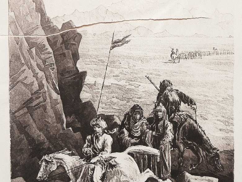
ELD 005 — Camp Safia in the Baluch Desert
Sepia-toned photo-lithograph of a wash sketch, showing two Anglo-Indian horsemen of the Bengal Lancers, arriving from the desert at a formation of bare rocks, where two fakirs in rags are standing. In the background a column is approaching.In the Lumsden Album, this lithograph is torn in two pieces.
Sepia-toned photo-lithograph of a wash sketch, showing two Anglo-Indian horsemen of the Bengal Lancers, arriving from the desert at a formation of bare rocks, where two fakirs in rags are standing. In the background a column is approaching.
In the Lumsden Album, this lithograph is torn in two pieces.
[Sketch, recto:] SAFIA / E D / 84.
[Sketch, verso:] –
[Lumsden Album:] SAFIA IN BILUCH DESERT.
[List:] (5) Safia a place in the Biluch desert.
[Sketch, verso:] –
[Lumsden Album:] SAFIA IN BILUCH DESERT.
[List:] (5) Safia a place in the Biluch desert.
- Owen, Charles (1884-86): Transcript of diary and letters, pp. 90-91: “7 Oct. [1884] We marched at 4 pm yesterday for Camp Safia, a distance of 18 miles. The road, or rather stony track, runs thro’ the Khanuk Pass. Our first halt was made at the top of the pass, (illegible) some 12 miles distant. The view from the Kotal was magnificent. The darkness of the brop (?) rocks being relieved by deposits of salt at their bases, which emphasises where the debris collects. There is a capital spring of sweet water at Khanuk. We halted 1½ hours at Khanuk to allow the camels to come up and reached camp about 1am. Our tents were pitched at 3am. Our camp at Safia was in the bed of a stream in a rocky defile. […]”
- Holdich, T.H. (1885): Afghan Boundary Commission; Geographical Notes, p. 43: “The line of march from Gazchah to Safia […] is a mere track winding and twisting over the successive waves of rolling stone-covered plateau hills, with the line of distant rugged peaks to the south; a few scattered isolated hills on the northern horizon, and one or two remarkable conical peaks rising straight up from the plain, forming a peculiarly definite line of landmarks for the marching force.”
- Yate, A.C. (1887): Travels with the Afghan Boundary Commission, p. 37: “[…] Safia, 14 miles – 2 wells and a tank. Water abundant. […]”
Image No.
ELD 005
Collection
Afghan Boundary Commission 1884-86
Series
ABC 4, ELD Sketches 001 to 053
Format
Original wash sketch, British Library WD 400, size 285/195 mmLithograph in the Lumsden Album 252/172 mm(88% of original size)
Place, date
Safia, October 7 to 9, 1884
Descriptors
Latitude / Longitude29.689781 / 64.688587
Google Earth29°41ʹ22ʺ N / 64°41ʹ18ʺ E / 1120 m
Google Mapshttps://maps.google.com
Zoom Earthhttps://zoom.earth
Survey of India MapSheet 34, Quetta (1922): Safia, R 46
You know more about this picture?


