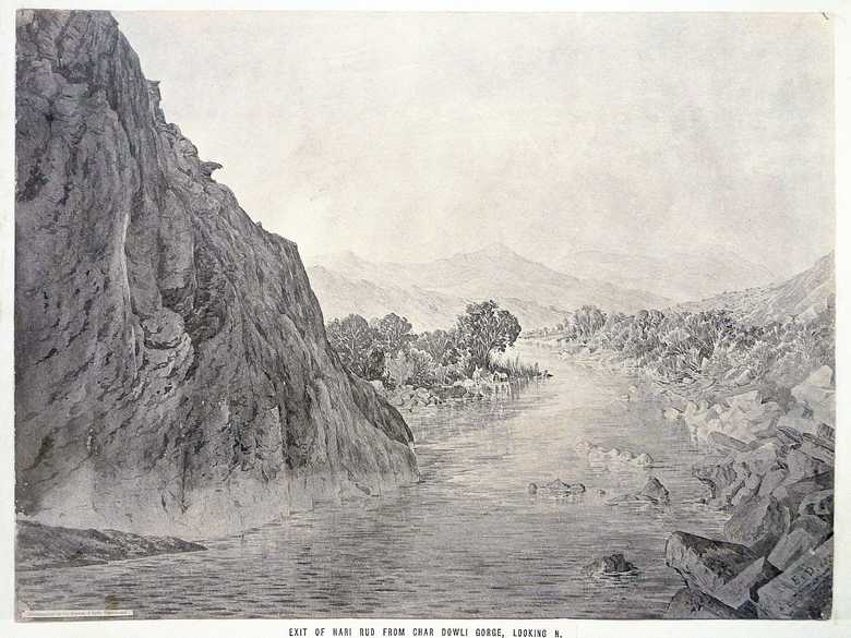
ELD 054 — Exit of the Hari Rud from the Char Dowli Gorge
Sepia-toned photo-lithograph of a wash sketch, showing the Hari Rud River leaving a gorge between steep rock faces. In this area the river forms the boundary between Afghanistan and Iran. On the left side is Persian territory, on the right it is Afghan.The identification of the exact location of ELD 053 and 054 is possible thanks to a photograph taken by Ehsan Hasani and published by Goggle Earth, showing the same site from the opposite direction (north).
Sample of texts on strips of white paper and glued on the lower margin of most of the photo-lithographs.
Sepia-toned photo-lithograph of a wash sketch, showing the Hari Rud River leaving a gorge between steep rock faces. In this area the river forms the boundary between Afghanistan and Iran. On the left side is Persian territory, on the right it is Afghan.
The identification of the exact location of ELD 053 and 054 is possible thanks to a photograph taken by Ehsan Hasani and published by Goggle Earth, showing the same site from the opposite direction (north).
[Sketch, recto:] E.D. 85. // Photographed by the Survey of India Department. // EXIT OF HARI RUD FROM CHAR DOWLI GORGE, LOOKING N.
[Sketch, verso:] (55) / Exit Hari Rud fr. Char Dowli Gorge looking North. Dec. 85.
[Lumsden Album:] The Har Rud River after watering the valley of Herat runs northwards through the Char Dowli Gorge, and after its junction with the … rud from Meshed becomes the “Tejend River” of which Sir Henry Rawlinson in the Royal Geographical Meeting [of June 22, published in the Proceedings of the RGS in] September 1885 observed as follows: [it follows a cutting from pp. 581-582]
[List:] (53) Exit of Hari Rud from Char Dowli Gorge, looking North.
- Lumsden, P. (1885): Countries and tribes bordering the Koh-i-Baba Range, pp. 577-583: Comments by Sir Henry Rawlinson.
- Peacocke, W (1887): Records of Intelligence Party ABC, Vol. 3, p. 229 (Oct. 9-11, 1885): “11th October. – Two miles above the Ab-i-Baghak the hills close in on both banks and the river issues in a succession of small waterfalls down a narrow gorge between lofty rock precipices. The gorge is a regular chasm, and its bed is choked with gigantic boulders. Even a clever cragsman would fail to find a way up it. It bars all progress up the river above this point.”
- Adamec, L.W. (1975): Herat and north-western Afghanistan, p. 318: Nehalshani. Describes this part of the Hari Rud, without mentioning the name Char Dowli. “Between Zulfikar and Tangi Malu there is no through road along the Hari Rud. In very dry weather the rocky bed of the river gorge is, it is said, passable on foot; but the track even then is too difficult to be of any practical use, and the rocky and precipitous nature of the gorge would put it out of the question to construct a road through it. […]”
Image No.
ELD 054
Collection
Afghan Boundary Commission 1884-86
Series
ABC 5, ELD Sketches 054 to 107
Format
Original wash sketch, British Library WD 450, size 305/405 mmLithograph in the Lumsden Album 262/350 mm(86 % of original size)
Place, date
Nehalshani, December, 1885
Descriptors
Latitude / Longitude35.401105 / 61.189500
Google Earth35°24ʹ00ʺ N / 61°11ʹ18ʺ E / 570 m
Google Mapshttps://maps.google.com
Zoom Earthhttps://zoom.earth
Survey of India MapSheet 29, Herat (1916): Nihalsheni, J 27
You know more about this picture?


